Showing 212 items matching rock groups
-
 Williamstown High School
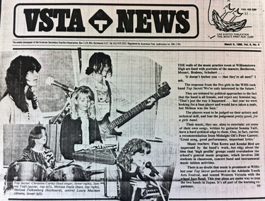
Top Secret - VSTA News article 1988
... Rock groups...VSTA news article about the all girl rock group from... the all girl rock group from Williamstown High School, touring ...VSTA news article about the all girl rock group from Williamstown High School, touring the western District in 1988. Photocopy of original article.williamstown high school, music, 1987, rock groups, all girl band -
 Stawell Historical Society Inc
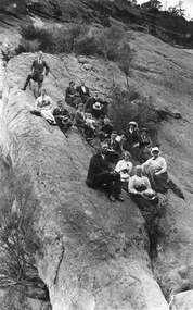
Photograph, Family Group Photo c1910
... Family Groups on rock face (possibly Grampians) ... Rathgeber (Sarah Anne) Family Groups on rock face (possibly ...Family Groups on rock face (possibly Grampians) Picnic at Concongella, In foreground Papa (J H) & Gran Rathgeber (Sarah Anne) -
 Bendigo Historical Society Inc.
Slide - Dunn's Rock Eppalock, 2012
... of the rock and a field group collecting date with Lake Eppalock...) Eppalock - Photos of the rock and a field group collecting date ...The low rolling hills of the Kimbolton countryside consist of ancient, hard and fractured Ordovician rock up to 65 million years old, which was originally deposited deep under the sea. Rocks mainly are sandstone, mudstone, black shale and quartz conglomerates. Marine fossils can be found in the area. Around seven million years ago a basalt flow buried the original bedrock along the along the Campaspe River. Ongoing weathering, wind and water movement over the following years has produced younger clay, sand, silt and gravel deposits throughout the area. Patches of White Hills Gravel are also found in the area. Another unique geological feature of this area is the Permian Glacial Pavement rocks north and south of Eppalock and glacial sediments (such as “Dunn’s Rock” and “Kellams Rock”). During the ice age (up to 280 million years ago) large glaciers moving over the countryside, scoured out sediments, pulverized bedrock, polished and cut grooves into bedrock in the direction of ice movement. When the ice melted boulders etc where left behind in areas of entirely different rock types, such as a 100 Tonne granite block known as ‘The Stranger’ near Derrinal. Dunn's Rock (Glaciated Pavement) Eppalock - Photos of the rock and a field group collecting date with Lake Eppalock (Knowsley) in the backgroundhistory, bendigo, dunn's rock eppalock, kimbolton forest, lake eppalock, gately collection -
 The Beechworth Burke Museum
Geological specimen - Basalt (igneous-volcanic) containing Olivine, unknown
... is the most common rock on Earth’s surface, more than 90% of all... is the most common rock on Earth’s surface, more than 90% of all ...This particular geological specimen was found in Mount Franklin or Lalgambook in Djadjawurrung, located between Daylesford and Newstead, approximately ninety minutes drive from Melbourne. The mountain is an example of a breached scoria cone (a steep conical hill of loose pyroclastic fragments) which was created by a volcanic eruption about 470,000 years ago, a date which may indicate the age of this geological specimen. The volcanic eruptions of Mount Franklin were most likely witnessed by members of the Dja Dja Wurrung Aboriginal tribe, who referred to this country as the 'smoking grounds'. Mount Franklin and the surrounding area appears to have been a place of considerable religious significance to Aboriginal people, there is evidence which indicates that frequent large ceremonial gatherings took place in the area. Basalt is the most common rock on Earth’s surface, more than 90% of all volcanic rock on Earth is basalt. Basalt is an aphanitic extrusive igneous rock formed from the rapid cooling of low-viscosity lava exposed at or very near the surface of a rocky planet or moon. Specimens are black in colour and weather to dark green or brown. Basalt is rich in iron and magnesium and is mainly composed of olivine, pyroxene, and plagioclase. Olivine is the name of a group of rock-forming silicate minerals with compositions ranging between Mg2SiO4 and Fe2SiO4. Unlike other minerals, Olivine has a very high crystallisation temperature which makes it the first of the minerals to crystallise from magma. As magma cools, the crystals begin to form and settle on the bottom of the lava and form basalts that are abnormally enriched in olivine in the lower part of lava flows. According to H. M. King (on geology.com) "Olivine is thought to be an important mineral in Earth's mantle. Its presence as a mantle mineral has been inferred by a change in the behaviour of seismic waves as they cross the boundary between Earth's crust and mantle". Lava from Mount Franklin and other volcanoes in the area filled valleys and buried the gold bearing streams that became the renowned ‘deep leads’ of the gold mining era. In 1852, as part of the Victorian gold rush, gold was discovered in the immediate area, this gold was created by lava flows during the Newer Volcanic period, which were mined intensively during the nineteenth century. Around 1865 the presence of a deep lead in Mount Franklin was established. Deep lead mining was initially unsuccessful, and it was not until the late 1870s that the Franklinford Gold Mining Company mined at Mount Franklin on a significant scale. A few years later the Mount Franklin Estate Gold Mining Company also struck gold, followed by the Shakespeare and Great Western companies in the mid-1880s. By the late 1880s, however, deep lead mining had ceased in the area. Soon after gold was discovered in 1851, Victoria’s Governor La Trobe wrote to the Colonial Office in London, urging ‘the propriety of selecting and appointing as Mineral Surveyor for this Colony a gentleman possessed of the requisite qualifications and acquaintance with geological science and phenomena’. Alfred Selwyn was appointed geological surveyor in Australia in 1852 which began the Geological Survey of Victoria. In 1853-69 the Geological Survey issued under Selwyn's direction sixty-one geological maps and numerous reports; they were of such high standard that a writer in the Quarterly Journal of the Geological Society of London bracketed the survey with that of the United States of America as the best in the world. During his years spent in Australia, Selwyn collected numerous significant geological specimens, examples of which are held in collections such as the Burke Museum.This geological specimen is an example of basalt and olivine which shows the volcanic lava activity and geographical specific nature of Mt Franklin as a significant volcanic site. According to Agriculture Victoria 'The crater is one of the deepest in the Central Highlands area. It is a major megacryst site with some of the largest known Victorian examples of megacrysts of augite and an orthoclase. The small parasitic mound of Lady Franklin on the western flanks adds to the geological interest of the site'. This specimen also highlights the locality as a significant place for both indigenous activity and Victorian gold rush era mining practices. This specimen is part of a larger collection of geological and mineral specimens collected from around Australia (and some parts of the world) and donated to the Burke Museum between 1868-1880. A large percentage of these specimens were collected in Victoria as part of the Geological Survey of Victoria that begun in 1852 (in response to the Gold Rush) to study and map the geology of Victoria. Collecting geological specimens was an important part of mapping and understanding the scientific makeup of the earth. Many of these specimens were sent to research and collecting organisations across Australia, including the Burke Museum, to educate and encourage further study.An angular, solid hand-sized piece of grey volcanic Basalt with green/brown Olivine phenocrysts along one flat edge.Olivine in basalt / - label is probably / correct. / C. Willman / 15/4/21burke museum, beechworth, indigo shire, beechworth museum, geological, geological specimen, mineralogy, basalt, igneous rock, igneous-volcanic, volcanic geology, volcanic, olivine, olivine specimen, basaltoid -
 The Beechworth Burke Museum
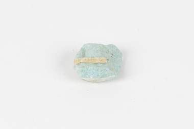
Geological specimen - Amazonite, unknown
Amazonite is classed as a Tectosilicate and is part of the Feldspar group of minerals. Amazonite forms in a triclinic crystal structure and its chemical formula is K(AlSi3O8). In appearance, Amazonite can range from shades of green to green blue to blue, and often with white streaks or veining. The greenish colour is believed to come from the small amount of lead contained in its composition. Amazonite is named after the Amazon River due to its colour and similarities to another rock found along the riverbanks, although Amazonite is not actually found at or near the Amazon. Although less commonly used in jewellery today, Amazonite has been mined and used by humans for thousands of years and Amazonite jewellery from at least 2000BCE have been discovered in North Africa. Amazonite is found in many locations around the world including Brazil, Peru, Ethiopia, Canada, Russia, Mozambique, Myanmar, Pakistan, China, Madagascar, and the United States of America. This specimen most probably comes from the U.S.A., Amazonite is found in several US states particularly in Colorado, Virginia, Pennsylvania. This specimen is of both scientific and historic significance as a striking blue green example of Amazonite mined prior to 1868 in the United States of America, most likely from Colorado, Virginia, or Pennsylvania. These three states are all locations of significant Amazonite deposits. This specimen is part of a larger collection of geological and mineral specimens collected from around Australia (and some parts of the world) and donated to the Burke Museum between 1868-1880. A large percentage of these specimens were collected in Victoria as part of the Geological Survey of Victoria that begun in 1852 (in response to the Gold Rush) to study and map the geology of Victoria. Collecting geological specimens was an important part of mapping and understanding the scientific makeup of the earth. Many of these specimens were sent to research and collecting organisations across Australia, including the Burke Museum, to educate and encourage further study.A palm-sized Feldspar mineral specimen from the Tectosilicate class in shades of blue-green with white veining.Existing label: green/blue Feldspar / "amazonite" / possibly USA geological specimen, geology, geology collection, burke museum, beechworth, tectosilicate, amazonite, feldspar, triclinic crystal structure, amazonite usa, amazonite colorado, amazonite virginia, amazonite pennsylvania -
 The Beechworth Burke Museum
Photograph, c. 1902
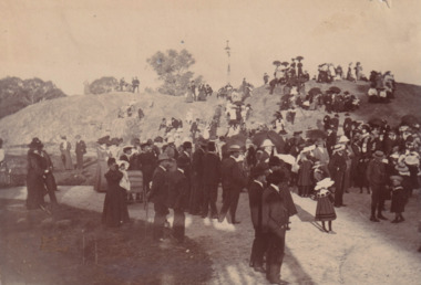
Taken in c. 1902, depicted is a group of adults and children dressed in formal clothing, with some of the women in the crowd carrying parasols, standing and sitting around and upon the rock at Queen Victoria Park on the Ford Street side of the park. This group is celebrating the official opening of the park. On top of the rock is a gas lamp post.Originally known as the Beechworth Botanical Gardens, the Queen Victoria Park features a extensive collection of historic trees and plants, which have been listed on the Indigo Shire’s Significant Tree Register. Sepia rectangular photograph printed on matte photographic paperReverse: 3716 (in black pen)/ 97.2273 (in pencil)/entertainment album, beechworth, queen victoria park, gardens & parks, opening, burke museum -
 The Beechworth Burke Museum
Photograph, c. 1905
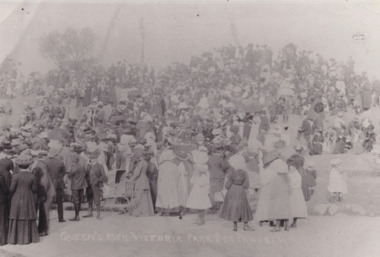
Taken in c. 1905, depicted is a large group of children and adults dressed in formal attire sitting and standing upon a granite rock that is located in the centre of Queen Victoria Park. In front of the group is a wooden picket wire fence that sides the granite rock. On top of the rock is a gas lamp post.Originally known as the Beechworth Botanical Gardens, the Queen Victoria Park features a extensive collection of historic trees and plants, which have been listed on the Indigo Shire’s Significant Tree Register.Black and white rectangular reproduced photograph printed on matte photographic paperReverse: 6956 (in pencil)/ ©/ DONALD HAYES/ BEECHWORTH (stamped in orange ink)/entertainment album, burke museum, beechworth, queen victoria park, park -
 The Beechworth Burke Museum
Postcard, c. 1903
Taken in c. 1903, depicted is a large group of adults and children dressed in formal attire gathered around and upon the granite rock in the centre of Queen Victoria Park.Originally known as the Beechworth Botanical Gardens, Queen Victoria Park features a extensive collection of historic trees and plants, which have been listed on the Indigo Shire’s Significant Tree Register.Black and white rectangular postcard printed on cardObverse: QUEEN'S ROCK VICTORIA PARK BEECHWORTH Reverse: 3701/ 3641 (this has been crossed out)/ Parks & Gardens/ 1998.00059/ entertainment album, burke museum, beechworth, queen victoria park, gardens & parks -
 The Beechworth Burke Museum
Photograph - Photograph - Reproduction, Unknown
This image is a reproduction of an 1899 original depicting the 'Williams Good Luck Mine' on the Mopoke Reef (also called 'Morepork Gully') in the Dingle Ranges, approximately three miles from Beechworth. The foreground of the image is littered with piles of smashed rock and detritus, known as ‘mullock’, beside a reinforced mine shaft, a vertical access passageway allowing miners to enter the mine and haul ore out using lifting technology such as a poppet heads, whims or windlasses. A group of miners and a dog appear close to an open-sided miner’s hut. Following the discovery of gold at Beechworth in 1852, rushes quickly followed at surrounding creeks and gullies in the district. In the late nineteenth and early twentieth centuries, small syndicates of miners continued to work old or abandoned quartz reefs, often persisting without the assistance of heavy machinery to remove the large amounts of rock, in order to obtain yields at ever greater depths. The group of miners in this photograph are Mr. Roger Williams and Sons, who revived operations at the ‘Old Good Luck’ mine on the Mopoke Reef in the Dingle Range near Beechworth around 1892, working the site for more than two decades. An emigrant from Cornwall with experience in the tin mining industry, 19 year old Roger Williams senior sailed to New Zealand in 1840, then to Australia where he spent time in the Bendigo Gold Fields before settling in Beechworth in the early 1860s. Mr Williams senior worked on various mining activities in the district, including the Rocky Mountain Tunnel project. Conversant with the character of gold-bearing reefs in the area, the syndicate dug an eight hundred foot tunnel, digging down as far down as two hundred feet with little capital save their labour, to connect and provide better working access to the mass of reefs and veins in the vicinity. Progress was hampered by poor air quality charged with fumes from dynamite and large quantities of rock had to be crushed to obtain payable yields. The Victorian Goldfields are filled with ruins and remnants of the area's rich mining history, ranging from small alluvial diggings to the remains of huge mining companies. Site names often changed several times throughout the nineteenth and twentieth centuries. Some sites were abandoned and forgotten, others were worked continuously over many decades. The names of mines were often repeated at different locations throughout the Victorian Goldfields. For example, there is a Mopoke Gully heritage mine near Fryers Creek, Victoria. 'Mopoke' is a common onomatopoeic name for Morepork and Australian Boobook owls. This image has historical, social and research significance for patterns of emigration during of the Victorian Gold Rush, and the historical, social and environmental impacts of mining at Beechworth at the turn of the nineteenth and twentieth centuries. As gold became scarce and government support and large company investment waned, poor hard-working miners laboured intensively to make a living through periods of high unemployment. This image can be compared and studied alongside other historical mining photographs and objects in the Burke Museum Collection. It has potential to improve our understanding of miners working conditions and the shifting character of mining in the Beechworth district. Black and white rectangular reproduction photograph printed on matte photographic paper.Obverse: Williams Good Luck Mine Beechworth / Roger! / Reverse: 6858 / burke museum, beechworth museum, beechworth, gold fields, gold rush, victorian gold rush, gold ming history, colonial australia, australian gold rushes, mining technology, beechworth historic district, indigo gold trail, migration, indigo shire, good luck gold mine, victorian goldfields, mining syndicates, gold fever, quartz-mining, small-scale mining, old good luck mine, mopoke gully, quartz reefs beechworth -
 Phillip Island and District Historical Society Inc.
Photograph, Near Forrest Caves, Phillip Island
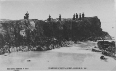
Part of a collection of 'Rose & Valentine' series of Post Cards. Copied by John Jansson 1984Black & White Postcard. View of rocks near Forrest Caves. Group of people on edge of the rock formation watching the waves.The Rose Series P3435. Near Forest Caves, Cowes, Phillip Island, Victorialocal history, photography, photographs, postcards, phillip island, black & white postcard copy, rock formation, forrest caves, phillip island -
 Lorne Historical Society
Photograph, Great Ocean Road. Road construction at Cathedral Rock. 1919
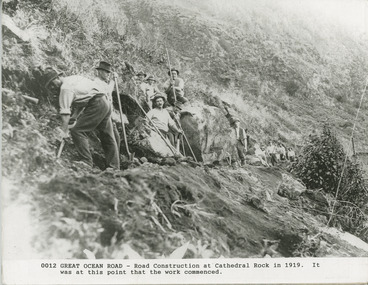
... Group of workmen. Cathedral Rock where the work commenced... Road. Road construction at Cathedral Rock. 1919 Group ...Group of workmen. Cathedral Rock where the work commencedstart of construction, great ocrean road. cathedral rock -
 Federation University Historical Collection
Photograph - Colour, Ballarat University College Engineering Graduates, 1993
Ballarat University College was a predecessor institution of Federation University Australia. A number of Engineering Students at Ballarat University College posing for a group photograph on the basketball court at Mount Helen Campus.ballarat university college, engineering, travis hawkins, michael trenorden, ray mahony, christopher macrae, jason rock, peter mah, wong chee keong, elangoo veerappan, kam jin khuon, steophen king, hoi kay woo, tracy whitbourn, tamsin mangan, nicole groves, bernadette righetti -
 Australian National Surfing Museum
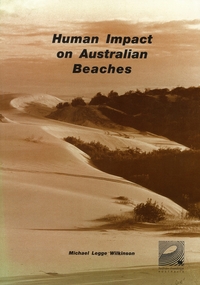
Document, Human Impact on Australian Beaches (Results from SOS95 Beach Survey), 1/5/1996 (estimated)
Human Impacts on Australian Beaches was a landmark environmental study which provided a 'snapshot' of the health of 1612 beach areas around Australia. This nationwide study (which built on the success of the 1994 State of Our Surf Report) was put together by the Surfrider Foundation Australia with the support of more then 340 individuals and 70 organisations around Australia. The report was authored by surfer/environmentalist/artist Michael Legge-Wilkinson from Newcastle, New South Wales. Human Impacts was launched officially by Peter Garrett, leader of Australian rock band Midnight Oil at the Bondi Pavilion, Bondi Beach in May 1996.Human Impacts built on the success of the 1994 State Of Our Surf Report, released by the Surfrider Foundation Australia in 1994. Human Impacts was the first major report to specifically examine the environmental health of 1612 of Australia's beaches. A limited 500 copies of this report were produced, the majority of which went to education institutions, libraries, community groups and government departments. The report generated national and international media interest with the BBC London reporting on its findings in the week after its launch.Beach Environmental Report. 168 page report which examines the health of 1612 beach areas around Australia. Sepia cover featuring a photograph of endangered sanddunes at Stockton Bight, north of Newcastle. 168 pagesSepia cover, Surfrider Foundation logo on report coverbeach, surfrider foundation australia, human impacts on beaches, sos95, michael legge wilkinson, coastal development, beach pollution -
 Bendigo Military Museum
Photograph - PHOTOGRAPHS WW2, 1940 - 1942
.7) Back row, Len STEVENS, Len TRIPP, Charles WOODWARD - ? 1st row, Les WARREN - ? Leonard Jordan TRIPP VX25096 2/24 BATT A.I.F K.I.A Alamein 24/10/42 Refer Cat No 205P for Len Tripps full service details..1) Photo, B&W on steel frame, photo surrounded by yellow edging, photo has plastic covering. Photo re L.J. TRIPP. .2) - .4) Photos, sepia colour, potrait re L.J. TRIPP. .5) Photo, B&W, shows group of 8 soldiers in Tin Hats and webbing. .6) Photo, B&W, shows group of 7 soldiers standing by a large rock. .7) Postcard photo, B&W, shows group of 6 soldiers outside a tent. .8) Postcard, cartoon B&W, with central inset photo of L.J. TRIPP..2) - .4) "Seymour 14.9.40" .7) "Merry Xmas & Happy New Year"photography-photographs, documents - postcards, military history -
 Kiewa Valley Historical Society
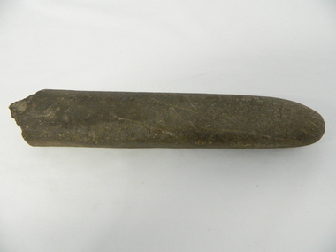
Grinder / Pounding Stone, Dhudhuroa language Aboriginal tribe, pre British/European colonisation
This stone Grinder or pounder was used as part of an indigenous grinding food preparation method, by the original inhabitants of the Kiewa Valley and its region. In conjunction with its grinding stone was used not only to grind seeds and but also to dig up eatable roots and leaves and served with the regions Bogong moth. This method of food preparation has survived in its basic form for centuries and is still used by master chiefs in modern eateries. This item has been registered with Aboriginal Affairs in Wangaratta, Victoria. Dhudhuroa elder Alan Murray has examined this tool, in Feb 2015, and said it was also used for sharpening axe heads as well as pounding food items. This item has a very significant historical and social aspect to it. Firstly it demonstrates the division of labour within a indigenous tribe. It was an era when the female had a definitive role within the family and the broader social indigenous tribal group of, gathering and preparing non animal(hunted) food. Hunted food was the domain of the initiated males of the tribe.Secondly it demonstrates the ability to fashion implements from raw materials(rock) into effective tools for the purpose of preparing a meal for human consumption. This was in an era where inter family and intra family participation in an indigenous tribal social protective environment was at a very high level. The Kiewa Valley/Mount Bogong region was an area where annual "get together" indigenous tribes for feasting, bartering and settling of disputes highlighting the importance of a regional gathering. Grooved stone, carved to a cylindrical shape with a relative pointed end tip one side (grinding or pounding end) and a rough other end (holding end} Made from Rhyolite stoneThere is a worn grove in the top side due to this tool being used for axe sharpening. indigenous, aboriginal, stone grinding, meal preparation, natural environment, pounding stone -
 Ringwood and District Historical Society
Photographs, 1979-80 MMBW pipe line project at Hubbard Reserve, North Ringwood � Boring mole pit
E560 N5 Dec 1979 A43 Boring mole pit near big box tree in 39 Burlock Avenue backyard Part of a 43-photo record of the MMBW�s engineering feat in drilling a 12 inch pipe line up to 40 feet deep through rock hardened by volcanic action associated with geological fault that occurs along the line. The work took place from October 1979 to May 1980 on the southern boundary of Hubbard Reserve, North Ringwood. The collection was presented to the Ringwood Historical Research Group by J Clarke on 9th June 1980. -
 Ringwood and District Historical Society
Photographs, 1979-80 MMBW pipe line project at Hubbard Reserve, North Ringwood � Back-hoe at pit
E560 N6 Dec 1979 A43 The back-hoe works on the beginnings of pit in 39 Burlock Avenue backyard Part of a 43-photo record of the MMBW�s engineering feat in drilling a 12 inch pipe line up to 40 feet deep through rock hardened by volcanic action associated with geological fault that occurs along the line. The work took place from October 1979 to May 1980 on the southern boundary of Hubbard Reserve, North Ringwood. The collection was presented to the Ringwood Historical Research Group by J Clarke on 9th June 1980. -
 Ringwood and District Historical Society
Photographs, 1979-80 MMBW pipe line project at Hubbard Reserve, North Ringwood � Cover of mole pit
E560 N24 Jan 1980 A43 Cover of mole pit near big box tree in 39 Burlock Avenue backyard Part of a 43-photo record of the MMBW�s engineering feat in drilling a 12 inch pipe line up to 40 feet deep through rock hardened by volcanic action associated with geological fault that occurs along the line. The work took place from October 1979 to May 1980 on the southern boundary of Hubbard Reserve, North Ringwood. The collection was presented to the Ringwood Historical Research Group by J Clarke on 9th June 1980. -
 Ringwood and District Historical Society
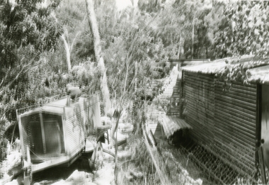
Photographs, 1979-80 MMBW pipe line project at Hubbard Reserve, North Ringwood � Compressor unit in backyard
Part of a 43-photo record of the MMBW�s engineering feat in drilling a 12 inch pipe line up to 40 feet deep through rock hardened by volcanic action associated with geological fault that occurs along the line. The work took place from October 1979 to May 1980 on the southern boundary of Hubbard Reserve, North Ringwood. The collection was presented to the Ringwood Historical Research Group by J Clarke on 9th June 1980.E560 N23 Jan 1980 A43 Compressor unit in backyard of 39 Burlock Avenue -
 Ringwood and District Historical Society
Photographs, 1979-80 MMBW pipe line project at Hubbard Reserve, North Ringwood � Work on boring mole pit
Part of a 43-photo record of the MMBW�s engineering feat in drilling a 12 inch pipe line up to 40 feet deep through rock hardened by volcanic action associated with geological fault that occurs along the line. The work took place from October 1979 to May 1980 on the southern boundary of Hubbard Reserve, North Ringwood. The collection was presented to the Ringwood Historical Research Group by J Clarke on 9th June 1980.E560 N22Jan 1980 A43 Work on mole boring pit in 39 Burlock Avenue backyard -
 Ringwood and District Historical Society
Photographs, 1979-80 MMBW pipe line project at Hubbard Reserve, North Ringwood � Filling at 29 Burlock Avenue
Part of a 43-photo record of the MMBW�s engineering feat in drilling a 12 inch pipe line up to 40 feet deep through rock hardened by volcanic action associated with geological fault that occurs along the line. The work took place from October 1979 to May 1980 on the southern boundary of Hubbard Reserve, North Ringwood. The collection was presented to the Ringwood Historical Research Group by J Clarke on 9th June 1980.E560 N10 Dec 1979 A43 Filling at 29 Burlock Avenue -
 Ringwood and District Historical Society
Photographs, 1979-80 MMBW pipe line project at Hubbard Reserve, North Ringwood � Filling behind 29 Burlock Avenue just off sewer line
Part of a 43-photo record of the MMBW�s engineering feat in drilling a 12 inch pipe line up to 40 feet deep through rock hardened by volcanic action associated with geological fault that occurs along the line. The work took place from October 1979 to May 1980 on the southern boundary of Hubbard Reserve, North Ringwood. The collection was presented to the Ringwood Historical Research Group by J Clarke on 9th June 1980.E560 N9 Dec 1979 A43 Filling behind 29 Burlock Avenue just off sewer line -
 Ringwood and District Historical Society
Photographs, 1979-80 MMBW pipe line project at Hubbard Reserve, North Ringwood � Filling at 29 Burlock Avenue
Part of a 43-photo record of the MMBW�s engineering feat in drilling a 12 inch pipe line up to 40 feet deep through rock hardened by volcanic action associated with geological fault that occurs along the line. The work took place from October 1979 to May 1980 on the southern boundary of Hubbard Reserve, North Ringwood. The collection was presented to the Ringwood Historical Research Group by J Clarke on 9th June 1980.E560 N11 Dec 1979 A43 Filling at 29 Burlock Avenue -
 Ringwood and District Historical Society
Photographs, 1979-80 MMBW pipe line project at Hubbard Reserve, North Ringwood � Closeup of revolving airwinch near Hibberd's house
Part of a 43-photo record of the MMBW�s engineering feat in drilling a 12 inch pipe line up to 40 feet deep through rock hardened by volcanic action associated with geological fault that occurs along the line. The work took place from October 1979 to May 1980 on the southern boundary of Hubbard Reserve, North Ringwood. The collection was presented to the Ringwood Historical Research Group by J Clarke on 9th June 1980.E560 N31 Jan 1980 A43 Closeup of revolving airwinch near Hibberd's house -
 Ringwood and District Historical Society
Photographs, 1979-80 MMBW pipe line project at Hubbard Reserve, North Ringwood � Grating over hole in Chalkley's 41 Burlock Avenue
Part of a 43-photo record of the MMBW�s engineering feat in drilling a 12 inch pipe line up to 40 feet deep through rock hardened by volcanic action associated with geological fault that occurs along the line. The work took place from October 1979 to May 1980 on the southern boundary of Hubbard Reserve, North Ringwood. The collection was presented to the Ringwood Historical Research Group by J Clarke on 9th June 1980.E560 N25 Jan 1980 A43 Grating over hole 37 feet deep in Chalkley's 41 Burlock Avenue (lot 8) -
 Ringwood and District Historical Society
Photographs, 1979-80 MMBW pipe line project at Hubbard Reserve, North Ringwood � View along line work in Hibberd's and Chalkley's
Part of a 43-photo record of the MMBW�s engineering feat in drilling a 12 inch pipe line up to 40 feet deep through rock hardened by volcanic action associated with geological fault that occurs along the line. The work took place from October 1979 to May 1980 on the southern boundary of Hubbard Reserve, North Ringwood. The collection was presented to the Ringwood Historical Research Group by J Clarke on 9th June 1980.E560 N27 Jan 1980 A43 View along line work in Hibberd's and Chalkley's (lot 9 and 8) -
 Ringwood and District Historical Society
Photographs, 1979-80 MMBW pipe line project at Hubbard Reserve, North Ringwood � Truck-mounted posthole digger that tried to sink shafts on MMBW sewer line behind 29-39 Burlock Avenue
Part of a 43-photo record of the MMBW�s engineering feat in drilling a 12 inch pipe line up to 40 feet deep through rock hardened by volcanic action associated with geological fault that occurs along the line. The work took place from October 1979 to May 1980 on the southern boundary of Hubbard Reserve, North Ringwood. The collection was presented to the Ringwood Historical Research Group by J Clarke on 9th June 1980.E560 N32 Feb 1980 A43 Truck-mounted posthole digger that tried to sink shafts on MMBW sewer line behind 29-39 Burlock Avenue. Four feet wide, the auger could only go down one metre and was nearly useless. -
 Ringwood and District Historical Society
Photographs, 1979-80 MMBW pipe line project at Hubbard Reserve, North Ringwood � View behind no. 39 Burlock Avenue showing compressor, mole pit cover and the big box tree
Part of a 43-photo record of the MMBW�s engineering feat in drilling a 12 inch pipe line up to 40 feet deep through rock hardened by volcanic action associated with geological fault that occurs along the line. The work took place from October 1979 to May 1980 on the southern boundary of Hubbard Reserve, North Ringwood. The collection was presented to the Ringwood Historical Research Group by J Clarke on 9th June 1980.E560 N26 Jan 1980 A43 View behind no. 39 Burlock Avenue showing compressor, mole pit cover and the big box tree -
 Ringwood and District Historical Society
Photographs, 1979-80 MMBW pipe line project at Hubbard Reserve, North Ringwood � Line of sewer work with mole power pack near Hibberd's shed
Part of a 43-photo record of the MMBW�s engineering feat in drilling a 12 inch pipe line up to 40 feet deep through rock hardened by volcanic action associated with geological fault that occurs along the line. The work took place from October 1979 to May 1980 on the southern boundary of Hubbard Reserve, North Ringwood. The collection was presented to the Ringwood Historical Research Group by J Clarke on 9th June 1980.E560 N28 Jan 1980 A43 Line of sewer work with mole power pack near Hibberd's shed -
 Ringwood and District Historical Society
Photographs, 1979-80 MMBW pipe line project at Hubbard Reserve, North Ringwood � View east, sewer work line showing grate over pit
Part of a 43-photo record of the MMBW�s engineering feat in drilling a 12 inch pipe line up to 40 feet deep through rock hardened by volcanic action associated with geological fault that occurs along the line. The work took place from October 1979 to May 1980 on the southern boundary of Hubbard Reserve, North Ringwood. The collection was presented to the Ringwood Historical Research Group by J Clarke on 9th June 1980.E560 N30 Feb 1980 A43 View east, sewer work line showing grate over pit